Skeda:Ethnographische Karte von Makedonien (1899).jpg
Madhësia e këtij shikimi: 520 × 600 pixel. Rezolucione të tjera: 208 × 240 pixel | 416 × 480 pixel | 666 × 768 pixel | 888 × 1.024 pixel | 1.776 × 2.048 pixel | 3.065 × 3.535 pixel.
Dokument origjinal ((përmasa 3.065 × 3.535 px, madhësia skedës: 1,14 MB, lloji MIME: image/jpeg))
| Kjo skedë është prej Wikimedia Commons dhe mund të përdoret nga projekte të tjera. Përshkrimi në këtë skedë në këtë faqe nuk është treguar më poshtë. | Shko tek faqja përshkruese në Commons |
.jpg)
Përmbledhje
| Përshkrimi |
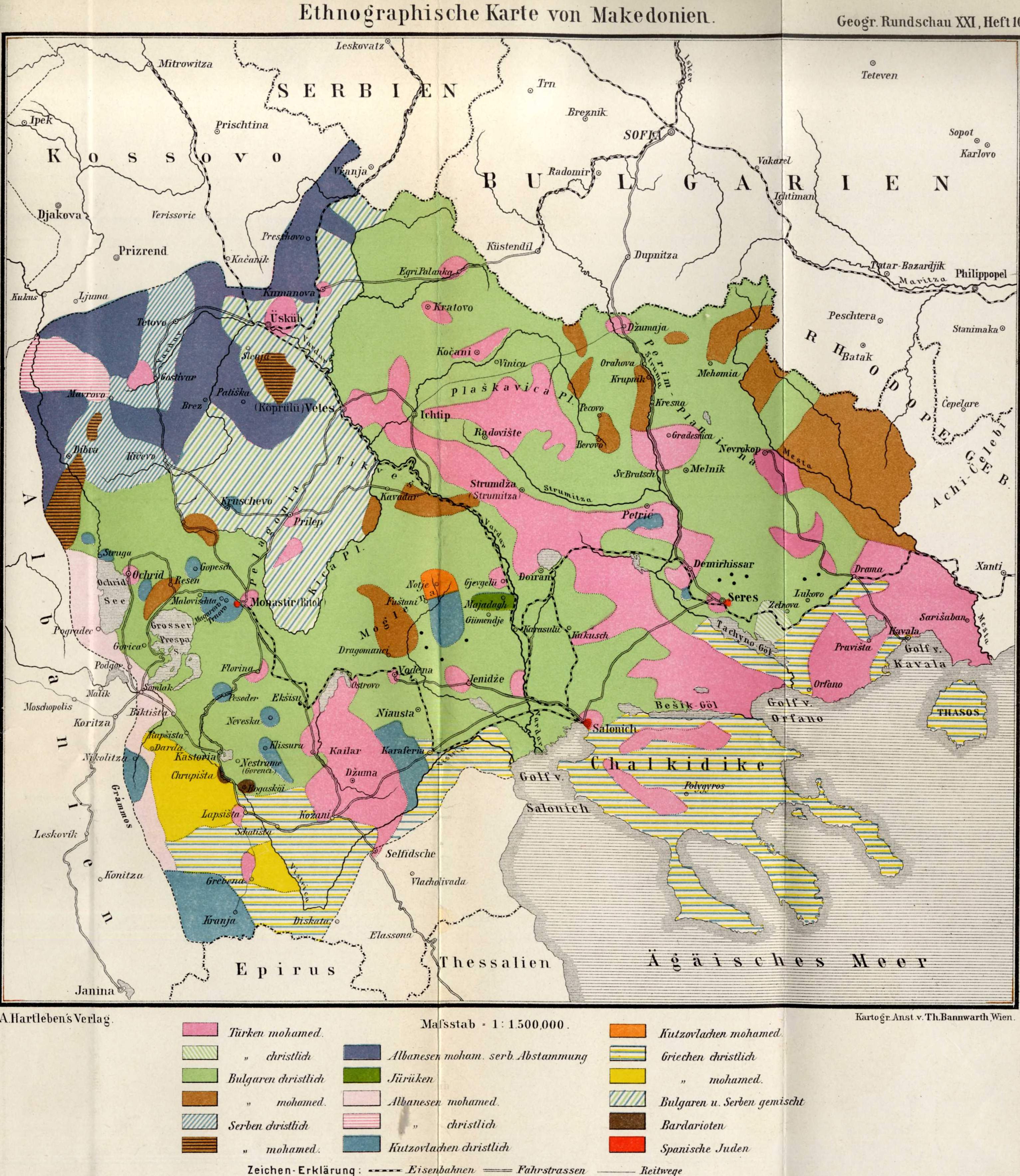
Ethnic map of Macedonia Dark pink = Turkish Muslims Diagonal green and white stripes = Christian Turks («Gagauzes») Light green = Christian Bulgarians («Slavic speakers») Light brown = Bulgarian Muslims («Pomaks») Diagonal blue and white stripes = Christian Serbs Horizontal black and brown stripes = Serb Muslims («Gorans», «Bosniaks» and «Torbeshi») Navy blue = Albanian Muslims with Serb origin Dark green = «Yörüks»: (Oghuz Turks from Anatolia) Light pink = Albanian Muslims («Tsamides, Chams») Horizontal pink and white stripes = Christian Albanians («Arvanites») Blue = Christian Aromanians («Vlachs») Orange = Aromanian Muslims («Moglenites») Horizontal blue and yellow stripes = Christian Greeks («Yunan rumlar») Yellow = Greek Muslims («Yunan mü'minler») Diagonal blue, white and green stripes = Bulgarians and Serbs mixed Dark brown = Bardoriots (supposed surviving «Vardariotai» observed by Pouqueville)Red = Spanish Jews («Ladino-Sefards»). The «Romaniots» may be confused with the Spanish Jews, or missing) |
| Data | |
| Burimi | Deutsche Rundschau für Geographie und Statistik Bd. XXI, Heft 10 [1] |
| Autori |
Friedrich Meinhard Scan: User:Olahus |
Licencim
|
This work is in the public domain in its country of origin and other countries and areas where the copyright term is the author's life plus 70 years or fewer. | |
| Kjo skedë është identifikuar si e lirë e kufizimeve të panjohura në ligjin e të drejtave të autorit, duke përfshirë të gjitha të drejtat e lidhura dhe fqinje. | |
Historiku skedës
Shtypni mbi një datë/kohë për ta parë skedën siç ishte atëherë.
| Data/Koha | Miniaturë | Përmasat | Përdoruesi | Koment | |
|---|---|---|---|---|---|
| e tanishme | 20 nëntor 2022 19:13 | | 3.065 × 3.535 (1,14 MB) | Ασμοδαίος | restoring previous version -- the new version uploaded by Gyalu22 renders some groups (such as the Kutzovlachen mohamed. and the Turken mohamed.) practically indistinguishable |
| 20 nëntor 2022 10:24 |  | 3.065 × 3.535 (4,66 MB) | Gyalu22 | levels | |
| 29 prill 2008 22:48 |  | 3.065 × 3.535 (1,14 MB) | Olahus | {{Information |Description=Ethnic map of Macedonia |Source=Deutsche Rundschau für Geographie und Statistik |Date=1892 |Author=own scan |Permission= |other_versions= }} Category:Maps of ethnic groups in Bulgaria [[Category:Maps of ethnic groups in Gr |
Lidhje skedash
Këto faqe lidhen tek kjo skedë:
Përdorimi global i skedës
Kjo skedë përdoret nga Wiki të tjera në vijim:
- Përdorimi në bg.wiki.x.io
- Përdorimi në de.wiki.x.io
- Përdorimi në el.wiki.x.io
- Përdorimi në en.wiki.x.io
- Përdorimi në fr.wiki.x.io
- Përdorimi në fr.wiktionary.org
- Përdorimi në hr.wiki.x.io
- Përdorimi në it.wiki.x.io
- Përdorimi në mk.wiki.x.io
- Përdorimi në ro.wiki.x.io
- Përdorimi në ru.wiki.x.io
- Përdorimi në sl.wiki.x.io
- Përdorimi në sr.wiki.x.io
- Përdorimi në uk.wiki.x.io
.jpg)