Skeda:Map-Francophone World.svg

Size of this PNG preview of this SVG file: 800 × 410 pixel. Rezolucione të tjera: 320 × 164 pixel | 640 × 328 pixel | 1.024 × 524 pixel | 1.280 × 656 pixel | 2.560 × 1.311 pixel | 2.757 × 1.412 pixel.
Dokument origjinal (skedë SVG, fillimisht 2.757 × 1.412 pixel, madhësia e skedës: 1,47 MB)
| Kjo skedë është prej Wikimedia Commons dhe mund të përdoret nga projekte të tjera. Përshkrimi në këtë skedë në këtë faqe nuk është treguar më poshtë. | Shko tek faqja përshkruese në Commons |

Any autoconfirmed user can overwrite this file from the same source. Please ensure that overwrites comply with the guideline.
Përmbledhje
| Përshkrimi |
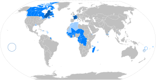
English: The French language in the world
States where French is the majority native language
(Dots: cities with native transmission, typically a minority) States where it is an official or administrative language
States where it is a culturally important language
The following things have been changed from the old "Map-Francophone World.png":
Français : La langue française dans le monde
Langue maternelle
Langue officielle ou administrative
Langue importante et/ou de culture
Les modifications par rapport à l'ancienne version "Map-Francophone World.png" sont :
Español: El idioma francés por el mundo
Lengua materna
Idioma oficial o administrativo
Idioma de importancia cultural
Català: La llengua francesa al món
Llengua materna
Llengua oficial
Segona Llengua Bahasa Indonesia: Bahasa Prancis di dunia
Negara dengan bahasa Prancis sebagai bahasa asli mayoritas
(Titik-titik: kota dengan penutur asli, biasanya minoritas) Negara dengan bahasa Prancis berstatus resmi atau digunakan dalam administrasi
Negara dengan bahasa Prancis berfungsi penting dalam budaya |
| Data | |
| Burimi | Punë e juaja |
| Autori | aaker (original PNG file: https://commons.wikimedia.org/wiki/File:New-Map-Francophone_World.PNG ) |
| Versione tjera |
|

Licencim
Unë, krijuesi i kësaj pune, e publikoj këtu në bazë të licensës në vijim:
This file is licensed under the Creative Commons Attribution-Share Alike 4.0 International license.
- Je i lirë të:
- ta shpërndani – ta kopjoni, rishpërndani dhe përcillni punën
- t’i bëni “remix” – të përshtatni punën
- Sipas kushteve të mëposhtme:
- atribuim – Duhet t’i jepni meritat e duhura, të siguroni një lidhje për tek licenca dhe të tregoni nëse janë bërë ndryshime. Këtë mund ta bëni në ndonjë mënyrë të arsyeshme, por jo në ndonjë mënyrë që sugjeron se licencuesi ju del zot juve apo përdorimit tuaj.
- share alike – Nëse bëni një “remix”, e shndërroni, ose ndërtoni duke u bazuar te materiali, duhet t’i shpërndani kontributet tuaja sipas të njëjtës licencë ose një të tille të përputhshme me origjinalen.
Historiku skedës
Shtypni mbi një datë/kohë për ta parë skedën siç ishte atëherë.
| Data/Koha | Miniaturë | Përmasat | Përdoruesi | Koment | |
|---|---|---|---|---|---|
| e tanishme | 2 shkurt 2025 13:40 | | 2.757 × 1.412 (1,47 MB) | Mastersun25 | update Karabakh |
| 19 tetor 2024 23:52 |  | 2.757 × 1.412 (1,47 MB) | IntelloFR | Reverted to version as of 03:15, 13 October 2024 (UTC) | |
| 13 tetor 2024 04:16 |  | 2.757 × 1.412 (1,47 MB) | SpinnerLaserzthe2nd | Reverted to version as of 03:09, 13 October 2024 (UTC) Never mind | |
| 13 tetor 2024 04:15 |  | 2.757 × 1.412 (1,47 MB) | SpinnerLaserzthe2nd | Changed Mali and Burkina Faso to light blue | |
| 13 tetor 2024 04:09 |  | 2.757 × 1.412 (1,47 MB) | SpinnerLaserzthe2nd | At least the Western Togoland part because the HSGF mentioned that 11 percent there speak French in the Western Togoland area | |
| 13 tetor 2024 04:01 |  | 2.757 × 1.412 (1,47 MB) | SpinnerLaserzthe2nd | I had emailed the HSGF (which is a group based in Ghana) and apparently, 11 percent of people speak French in Western Togoland | |
| 18 dhjetor 2023 20:24 |  | 2.757 × 1.412 (1,47 MB) | Kwamikagami | french is still the language of govt in Mali -- consistency w USA in English map | |
| 28 tetor 2023 02:55 |  | 2.757 × 1.412 (1,47 MB) | Salvabl | Mauritania's color fixed according to what it is stated in the description. | |
| 11 tetor 2023 03:08 |  | 2.757 × 1.412 (1,47 MB) | Salvabl | Colors uniformity fixed. | |
| 11 tetor 2023 02:56 |  | 2.757 × 1.412 (1,47 MB) | Salvabl | The standard on Wikipedia's world maps is the existence of a border between Morocco and Western Sahara. This is in accordance with the internationally recognized Moroccan borders. Therefore, the fact that French is a widely used language in Morocco is insufficient reason in this case. Either way, the Western Sahara territory could be highlighted if there were more than 20% French speakers within it. |
Lidhje skedash
Këto faqe lidhen tek kjo skedë:
Përdorimi global i skedës
Kjo skedë përdoret nga Wiki të tjera në vijim:
- Përdorimi në af.wiki.x.io
- Përdorimi në als.wiki.x.io
- Përdorimi në ar.wiki.x.io
- Përdorimi në ar.wikiversity.org
- Përdorimi në ary.wiki.x.io
- Përdorimi në arz.wiki.x.io
- Përdorimi në ast.wiki.x.io
- Përdorimi në azb.wiki.x.io
- Përdorimi në az.wikibooks.org
- Përdorimi në ban.wiki.x.io
- Përdorimi në be-tarask.wiki.x.io
- Përdorimi në beta.wikiversity.org
- Përdorimi në be.wiki.x.io
- Përdorimi në bg.wiki.x.io
- Përdorimi në bh.wiki.x.io
- Përdorimi në bn.wiki.x.io
- Përdorimi në bxr.wiki.x.io
- Përdorimi në ca.wiki.x.io
- Përdorimi në ca.wikiquote.org
- Përdorimi në ce.wiki.x.io
- Përdorimi në cs.wiki.x.io
- Përdorimi në cs.wikiversity.org
- Përdorimi në dag.wiki.x.io
- Përdorimi në da.wiki.x.io
- Përdorimi në da.wikibooks.org
- Përdorimi në de.wiki.x.io
- Përdorimi në de.wikibooks.org
- Përdorimi në de.wikiversity.org
- Përdorimi në de.wikivoyage.org
- Përdorimi në de.wiktionary.org
- Përdorimi në dtp.wiki.x.io
- Përdorimi në el.wikivoyage.org
- Përdorimi në el.wiktionary.org
- Përdorimi në en.wiki.x.io
Shikoni më shumë përdorim global të kësaj skede.