Skeda:Maritime zones of South Africa.svg

Size of this PNG preview of this SVG file: 484 × 599 pixel. Rezolucione të tjera: 194 × 240 pixel | 388 × 480 pixel | 620 × 768 pixel | 827 × 1.024 pixel | 1.654 × 2.048 pixel | 681 × 843 pixel.
Dokument origjinal (skedë SVG, fillimisht 681 × 843 pixel, madhësia e skedës: 131 KB)
| Kjo skedë është prej Wikimedia Commons dhe mund të përdoret nga projekte të tjera. Përshkrimi në këtë skedë në këtë faqe nuk është treguar më poshtë. | Shko tek faqja përshkruese në Commons |
Përmbledhje
| Përshkrimi |
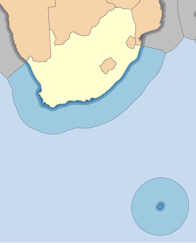
English: Map depicting the various maritime zones of South Africa including the Prince Edward Islands. Note that the boundaries depicted here do not represent official boundaries and have no legal status whatsoever. Projection: Lambert Conformal Conic.
Afrikaans: Kaart wat die onderskeie maritime sones van Suid-Afrika en die Prins Edward-eilandgroep aandui. Let daarop dat hierdie afbakening nie amptelike grense verteenwoordig nie, en oor geen regstatus beskik nie. Aangedui van donker- na ligblou is die Binnelandse waters, Territoriale waters, Aanliggende waters, Eksklusiewe ekonomiese sones en Internasionale waters. |
| Data | |
| Burimi |
|
| Autori | Htonl |
| Versione tjera | File:Maritime zones of the South African mainland.svg |
Licencim
| Unë,krijuesi i kësaj pune, e lëshoj këtë punë në public domain. Kjo aplikohet në të gjithë botën. Në disa vende kjo mund të mos jetë e mundur ligjërisht; nëse është kështu: Unë i garantoj çdokujt të drejtën për ta përdorur këtë punë për çdo qëllim, pa asnjë kusht, përveç rasteve kur këto kushte janë të kërkuara nga ligji. |
Historiku skedës
Shtypni mbi një datë/kohë për ta parë skedën siç ishte atëherë.
| Data/Koha | Miniaturë | Përmasat | Përdoruesi | Koment | |
|---|---|---|---|---|---|
| e tanishme | 22 shkurt 2014 17:52 | | 681 × 843 (131 KB) | Htonl | Redraw with conic projection |
| 26 mars 2010 01:45 |  | 902 × 872 (603 KB) | Htonl | == Summary == {{Information |Description={{en|1=Map depicting the various maritime zones of South Africa including the Prince Edward Islands. <font color="red">'''Note that the boundaries depicted here do not represent official boundaries and have no lega |
Lidhje skedash
Këto faqe lidhen tek kjo skedë:
Përdorimi global i skedës
Kjo skedë përdoret nga Wiki të tjera në vijim:
- Përdorimi në en.wiki.x.io
- Përdorimi në fr.wiki.x.io
- Përdorimi në kn.wiki.x.io